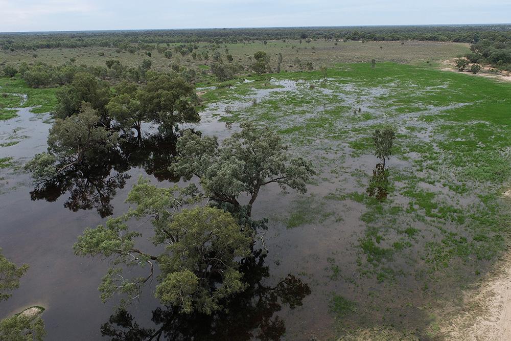
Drone images of the Western Floodplain in April 2024 showing the lead of the flow moving into the wetland. Photo credit: Matt Miles (New South Wales Department of Climate Change, Energy, Environment and Water-Biodiversity and Conservation).
Drone images of the Western Floodplain in April 2024 showing the lead of the flow moving into the wetland. Photo credit: Matt Miles (New South Wales Department of Climate Change, Energy, Environment and Water-Biodiversity and Conservation).
Brolga, freckled ducks, white-bellied sea eagles, coolibah, black-box, lignum and many aquatic grasses are just some of the native fauna and flora that have benefitted from water for the environment delivered to the Western Floodplain at Toorale National Park in western New South Wales.
The Western Floodplain is a large wetland complex covering over 10,000 ha between the western bank of the Warrego River and the Darling-Baaka River, around 50 kms west of Bourke.
Drone image of the Western Floodplain in April 2024 showing the lead of the flow moving into the wetland. Photo credit: Matt Miles (New South Wales Department of Climate Change, Energy, Environment and Water-Biodiversity and Conservation).
The Commonwealth Environmental Water Holder (CEWH) works with the New South Wales Department of Climate Change, Energy, Environment and Water-Biodiversity and Conservation (NSW DCCEEW-BCS) to assess the environmental demands of the Western Floodplain. Once flow target provisions for the Warrego and Darling rivers are met under the Toorale Operations Management Plan, NSW DCCEEW-BCS and National Parks and Wildlife Service operate infrastructure at the site to allow water onto the floodplain.
To support the health of the Western Floodplain, the CEWH delivered 8.4 gigalitres (GL) of environmental water from March – May this year, using a high-flow licence. The Commonwealth’s licenses entitle the CEWH to access 9.7 GL if flow triggers are met.
Monitoring under the CEWH’s science program by the University of New England and environmental consultant 2ROG is demonstrating that the watering is supporting ecological benefits including expanded and extended inundation of the floodplain vegetation.
The monitoring team has observed a flush in green growth in groundcover species such as sedges, lignum, and key floodplain tree species such as River Cooba and Coolibah. This bodes well for the ongoing health of key floodplain habitats that support a range of waterbirds, frogs and other floodplain species.
The use of the CEWH licence and amount of water being debited from our accounts is monitored carefully. At the Western Floodplain, NSW DCCEEW-BCS conducts these calculations using a measurement and calculation process that is set out in the operations plan for the area. With information from river gauges and water levels at Boera Dam, the water amount is recorded and debited from the Commonwealth’s licenses. As well as the environmental benefits of the floodplain watering, the water for the environment delivery is important for building resilience in the system to better survive once dry conditions return in coming years.
More than 60 GL of the Commonwealth’s water has been protected in the main stem of the Barwon-Darling this water year. This water is water that has been left in the Barwon-Darling as a result of the CEWH accounting for water against the Commonwealth’s licences.
Satellite images of the Western Plains – the first on 20 January 2024 and the second on 12 May 2024 – demonstrating the difference in conditions. Information from: Matt Miles (New South Wales Department of Climate Change, Energy, Environment and Water-Biodiversity and Conservation).